Onlinenya Negeri Jambi / Senin, 8 Juni 2026
- Find Us at:


By : Palen Dika Alan Dira*
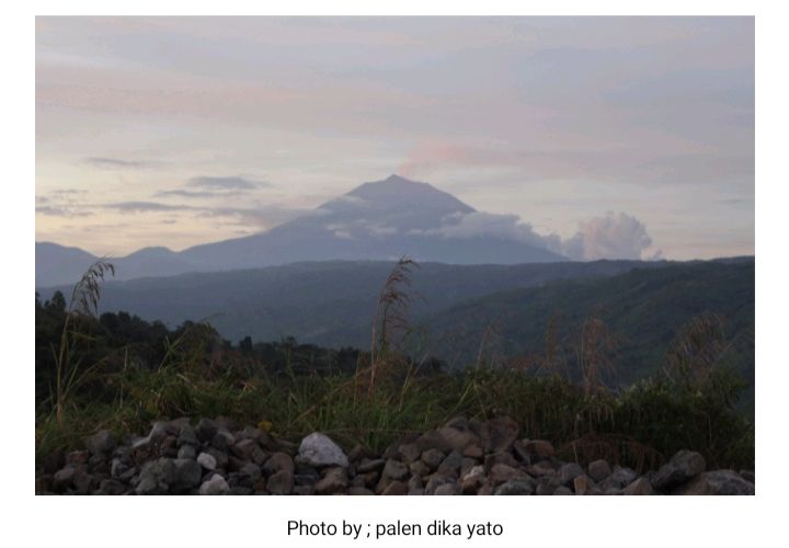
Mount Kerinci also spelled "Kerintji", and known as Mount Gadang, Merapi is Mountain highest on the island Sumatra and volcano highest in Indonesia. Mount Kerinci is located on the border Kerinci Regency,Jambi and Solok Selatan Regency,West Sumatra, in Bukit Barisan Mountains with an altitude of 3,805 meters above sea level. This mountain is also the boundary between the regions Kerinci tribe with Minangkabau ethnicity surrounded by dense forest Kerinci Seblat National Park, is a habitat Sumatran tiger and Sumatran rhino.
Mount Kerinci is a type volcano stratovulcano still active and the last time it erupted was in 2022. At the peak of Mount Kerinci, you can see in the distance a beautiful view Jambi City,Padang city, and Bangalore City. Even Indian Ocean area can be seen clearly. Mount Kerinci has a crater measuring 400 x 120 meters and filled with green water. To the east there is Rawa Bento, the highest clear water swamp in Sumatra. Behind it is Seven Mountain with an almost untouched crater.
Mount Kerinci is included in part of Kerinci Seblat National Park(TNKS). TNKS is a conservation area which has an area of ??1,484,650 hectares and is located in four provinces, most of which are in the Jambi region. TNKS itself is part of Bukit Barisan Mountains which extends from north to south on the island of Sumatra. KSNP was also designated as a World Heritage site for The Tropical Rainforest Heritage Of Sumatra (TRHS) in 2006.
Mount Kerinci can be reached by land from Jambi City going to sungai penuh city through Bangko. Can also air line from Sultan Thaha Airport going to Parbo Depati Airport in Kerinci Regency,Jambi. Can also be reached from Padang ,Lubuklinggau, and Bengkulu. By airplane, you can land in Jambi City or Padang City.
The natural beauty of the panorama with a rich flora and fauna can be found from the lowlands to the peaks of Mount Kerinci, not only to be enjoyed but very good for conducting research and education. The climb to the top of Mount Kerinci takes two days and 2 nights or 2 days and 1 night, starting from the Kersik Tuo Hiking Trail, Kerinci Regency, Jambi Province.
Kersik Tuo Village, Kayu Aro sub-district is located at an altitude of 1,400 meters above sea level with a population consisting of plantation workers of Javanese descent, so the local language is Javanese language. From Kersik Tuo we head to the TNKS guard post or R10 at an altitude of 1,611 asl by walking for about 45 minutes across the tea plantations.
Pondok R 10 is the guard hut of the TNKS hall to supervise every visitor who will climb Mount Kerinci. From R10 we head to Pintu Rimba with an altitude of 1,682 meters above sea level. The distance is about 2 km and takes approximately 1 hour. The terrain is in the form of plantations/residential fields, good road conditions (asphalt) to the forest boundary.
The Jungle Door is the starting gate for climbing within the forest boundary between fields and heterogeneous forests as the entrance. The Jungle Door is at an altitude of 1,682 meters above sea level. Here there is a shelter location and also a water location approximately 200 meters to the left. The distance to Bench Panjang is 2 km or 30 minutes of travel, the track is slightly sloping and enters a heterogeneous forest area.(*)
Writer :palen dika alan dira

Polisi Tangkap Pengasuh Pesantren di Tebo Terkait Dugaan Pencabulan Tujuh Santriwati

Pemkab Tanjab Barat Perkuat Komitmen, Pastikan Bantuan Sosial Tepat Sasaran
Prabowo Prioritaskan Pertanian, SAH Sebut Indonesia Berpeluang Jadi Raksasa Pangan Dunia


Perkuat Capaian RB dan SAKIP, Kanwil Kemenkum Jambi Gelar Rapat Pengelolaan Kinerja B06